


438
Pazifik
1 Bl. Mar de Sud ... Mare Pacifico (Coronelli)., 1691.
Estimate:
€ 1,000 / $ 1,150 Sold:
€ 1,353 / $ 1,555 (incl. surcharge)
438
Pazifik
1 Bl. Mar de Sud ... Mare Pacifico (Coronelli)., 1691.
Estimate:
€ 1,000 / $ 1,150 Sold:
€ 1,353 / $ 1,555 (incl. surcharge)
Pazifik
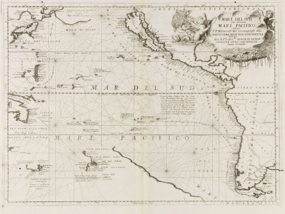
Mare del Sud, detto altrimenti Mare Pacifico. Kupferstich bei Vincenzo M. Coronelli, Venedig 1691. 45,5 : 61,5 cm.
Detaillierte Seekarte des Pazifik, die das Gebiet zwischen Japan, Neu-Guinea und Australien sowie der Westküste Nord- und Südamerikas zeigt.
Japan wird mit "Terra de Iesso" bezeichnet und, wie auch Neu-Guinea und Australien, jeweils nur mit angedeuteten Küstenlinien gezeigt. Kalifornien wird hier als Insel dargestellt. Die große Rocaille-Titelkartusche ist mit figürlichem und ornamentalem Beiwerk und Wappen geschmückt. - "This map is a further example of Coronelli's ornate work .. depicts the route of Jacob Le Maire and William C. Schouten through the Pacific 1615-17. This was one of the more crucial voyages as it proved by sailing around Cape Horn that Tierra del Fuego was an island .. Only one state is known although a crack did develop in the lower right margin above Tierra del Fuego" (Burden). Hier ein späterer Abdruck, d. h. der von Burden erwähnte Riß in der Platte ist deutlich erkennbar.
ZUSTAND: Mittelfalte nur gering leimschattig, ansonsten ein schönes und sauberes Blatt.
LITERATUR: McLaughlin/M. 104. - Burden 680. - Wagner 436.
Fine engraving of the Pacific, depicting Japan, part of the coastlines of New Guinea and Australia, and the western coast of North and South America (with insular California). Later print of the only known state of the map, the crack in the plate near Tierra del Fuego already developed into the illustration. - Centrefold only slightly gluestained, otherwise a fine and clean copy of the map.

Headquarters
Joseph-Wild-Str. 18
81829 Munich
Phone: +49 89 55 244-0
Fax: +49 89 55 244-177
info@kettererkunst.de
Louisa von Saucken / Undine Schleifer
Holstenwall 5
20355 Hamburg
Phone: +49 40 37 49 61-0
Fax: +49 40 37 49 61-66
infohamburg@kettererkunst.de
Dr. Simone Wiechers / Nane Schlage
Fasanenstr. 70
10719 Berlin
Phone: +49 30 88 67 53-63
Fax: +49 30 88 67 56-43
infoberlin@kettererkunst.de
Cordula Lichtenberg
Gertrudenstraße 24-28
50667 Cologne
Phone: +49 221 510 908-15
infokoeln@kettererkunst.de
Hessen
Rhineland-Palatinate
Miriam Heß
Phone: +49 62 21 58 80-038
Fax: +49 62 21 58 80-595
infoheidelberg@kettererkunst.de
We will inform you in time.