


83
Pablo Picasso
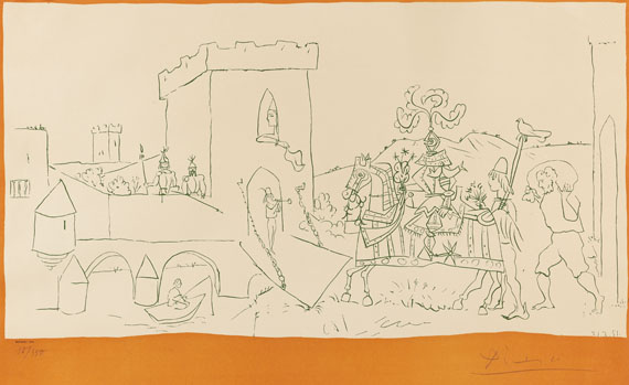
L´arrivée du Chevalier, 1951.
Lithograph
Estimate:
€ 2,000 / $ 2,360 Sold:
€ 2,125 / $ 2,507 (incl. surcharge)
L´arrivée du Chevalier. 1951.
Lithograph in green black with orange brown framing.
Neither in Bloch nor in Mourlot. Signed and numbered. Dated in stone. With typographic inscription "Mourlot Lith.". Verso typographically inscribed: "L'Arivée du Chevalier Réduction de la Peinture de Picasso 3m73 x 1m80 Vallauris 1951". From an edition of 350 copies. On firm paper. 48 x 75,5 cm (18,8 x 29,7 in), size of sheet. [DB].

83
Pablo Picasso
L´arrivée du Chevalier, 1951.
Lithograph
Estimate:
€ 2,000 / $ 2,360 Sold:
€ 2,125 / $ 2,507 (incl. surcharge)
Headquarters
Joseph-Wild-Str. 18
81829 Munich
Phone: +49 89 55 244-0
Fax: +49 89 55 244-177
info@kettererkunst.de
Louisa von Saucken / Undine Schleifer
Holstenwall 5
20355 Hamburg
Phone: +49 40 37 49 61-0
Fax: +49 40 37 49 61-66
infohamburg@kettererkunst.de
Dr. Simone Wiechers / Nane Schlage
Fasanenstr. 70
10719 Berlin
Phone: +49 30 88 67 53-63
Fax: +49 30 88 67 56-43
infoberlin@kettererkunst.de
Cordula Lichtenberg
Gertrudenstraße 24-28
50667 Cologne
Phone: +49 221 510 908-15
infokoeln@kettererkunst.de
Hessen
Rhineland-Palatinate
Miriam Heß
Phone: +49 62 21 58 80-038
Fax: +49 62 21 58 80-595
infoheidelberg@kettererkunst.de
We will inform you in time.