


192
Weltkarte
Nova totius terrarum orbis tabula (Wit/Ottens), um 1745.
Colored copper engraving
Estimate:
€ 2,000 / $ 2,300 Sold:
€ 1,875 / $ 2,156 (incl. surcharge)
192
Weltkarte
Nova totius terrarum orbis tabula (Wit/Ottens), um 1745.
Colored copper engraving
Estimate:
€ 2,000 / $ 2,300 Sold:
€ 1,875 / $ 2,156 (incl. surcharge)
Frederick de Wit
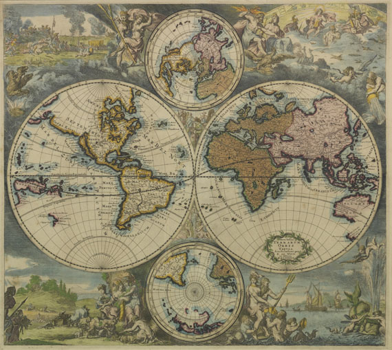
Nova totius terrarum orbis tabula. Kolorierter Kupferstich von Romyn de Hoghe für Frederick de Wit. Amsterdam, R. und J. Ottens 1745. 48 : 55 cm.
Weltkarte in zwei Hemisphären mit reichem figürlichen Schmuck.
Dritte Ausgabe der um 1670-75 erstmals in De Wits Seeatlas Orbis maritimus erschienenen Weltkarte. Zeigt Kalifornien als Insel, und den größten Teil der Küstenlinie Australiens. - "Fine maritime map .. Somewhat unusually the two main hemispheres have been engraved and the surrounding illustrations etched. In the corners are large and lively scenes allegorically representing the four elements .. There are groups of figures between the hemispheres and, above and below them, two smaller polar maps." (Shirley)
- ZUSTAND: Stellenweise leicht fleckig, das Flächen- und Grenzkolorit im Kartenbild leicht oxidiert. Unter Glas und Passepartout gerahmt, nicht geöffnet.
LITERATUR: Shirley 444, 3 (von 4).
Third state (of 4) of De Wit's richly embellished maritime world map in two hemispheres, published by R. and J. Ottens. - Occasionally slightly stained, colors of the map illustrations partly slightly oxidated. Matted and framed, not opened.(R)

Headquarters
Joseph-Wild-Str. 18
81829 Munich
Phone: +49 89 55 244-0
Fax: +49 89 55 244-177
info@kettererkunst.de
Louisa von Saucken / Undine Schleifer
Holstenwall 5
20355 Hamburg
Phone: +49 40 37 49 61-0
Fax: +49 40 37 49 61-66
infohamburg@kettererkunst.de
Dr. Simone Wiechers / Nane Schlage
Fasanenstr. 70
10719 Berlin
Phone: +49 30 88 67 53-63
Fax: +49 30 88 67 56-43
infoberlin@kettererkunst.de
Cordula Lichtenberg
Gertrudenstraße 24-28
50667 Cologne
Phone: +49 221 510 908-15
infokoeln@kettererkunst.de
Hessen
Rhineland-Palatinate
Miriam Heß
Phone: +49 62 21 58 80-038
Fax: +49 62 21 58 80-595
infoheidelberg@kettererkunst.de
We will inform you in time.